交河故城篇
作者:吐鲁番博物馆 吐鲁番学研究院


沙河二水自交流,天设危城水上头。
断臂悬崖多险要,荒台废址几春秋。
羌儿走马应辞苦,胡女逢人不解羞。
使节直穷西域去,岸花漫草莫相留。
——【明】陈城《崖儿城》
交河故城篇
Yar City
交河故城是公元前2世纪至公元14世纪丝绸之路东天山南麓吐鲁番盆地的中心城市,公元前1世纪发展为西域古国车师前国的国都,此后历为高昌国、唐西州、高昌回鹘王国等下辖的交河郡或交河县。公元640年,唐置安西都护府于交河城,成为唐帝国控制天山南部乃至西域广大地区的重要行政、军事、交通、宗教中心。交河故城依托自然台地的选址特征、独具匠心的城市布局、天然浑厚的建造技艺、形制多样的建筑遗存以及城址周边的墓葬和石窟,见证了古代西域地区车师、高昌国、高昌回鹘等文明,见证了“都护府”等边疆管理模式及其对丝路畅通交流的重要保障,展现了丝绸之路沿线有关城市文化、建筑技术、佛教及民族文化的交流与传播。
Yar City was an important central town on the Silk Roads from the 2nd century BC to the 14th century.It is located in the Turpan Basin on the southern side of the eastern Tian-shan Mountains.In the 1st century AD,it became the capital city of the Jushi Kingdom; subsequently,it variously held the status of a prefecture or a county under the Kingdom of Qocho,the Tang Dynasty and the Uyghur Kingdom of Qocho.In 640,the Tang Empire established Anxi Protectorate in Yar City,transforming the city into an important administrative,military, religious,and communication hub from which the empire controlled the south of the Tian-shan Mountains and the Western Regions.Built on a distinctive high natural terrace,the city was characterized by a unique urban layout that ingeniously utilized the natural landscape and displayed exquisite architectural artistry.The site is home to a diversity of architectural ruins,as well as several cemeteries and caves in the areas surrounding the ruins.These remnants bear witness to the ancient cultures of the Kingdom of Jushi,the Kingdom of Qocho,the Uyghur Kingdom of Qocho,and other cultures.The site also illustrates the"protectorate system" of rule and how this mode of frontier management ensured the smooth flow of traffic along the Silk Roads.The city is a physical proof of how the ethnic groups along the Silk Roads interacted and transmitted diverse urban cultures,architectural skills,Buddhism,and ethnic cultures.
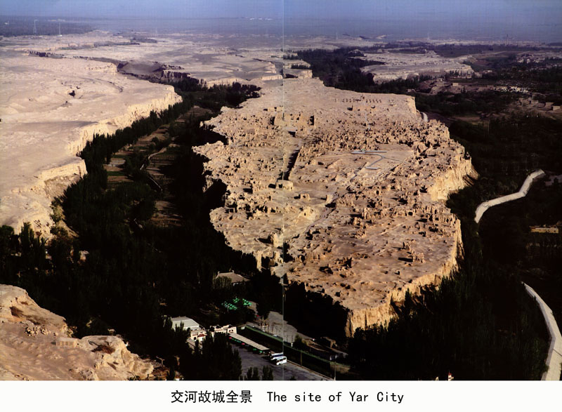
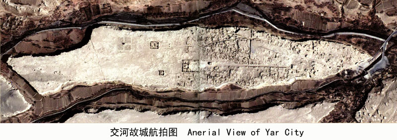
交河故城坐落于吐鲁番市西郊约10公里的雅尔乃孜沟谷环抱的台地上,平面呈柳叶形,台地最长处约1750米,最宽处约300米,总面积37.9万平方米,建筑面积22万平方米,四周崖壁陡峭,最大落差达30米,形成天然屏障。现存城市形制依然保留着不同历史时期、不同性质且风格迥异的建筑遗存,择中立衙、大道连街、门临小巷具有中原城市的布局特征,而佛教大寺院正门——中央大道——城门的布局则受中亚城市影响。城市建筑中采用的“压地起凸法”、“垛泥法”挖地为穴、夯土为墙、拱砌窑洞等技艺流传至今。交河城那宽阔的大道、宏伟的大佛寺,构思巧妙的官署、错落有致的民居、戒备森严的东门、排列有序的塔林,乃世界建筑史的奇迹,彰显了交河城当年贸易的繁荣与佛教的兴盛。
Yar City is located approximately 10 km to the west of Turpan City,on a willow-leaf-shaped distinctive high natural terrace surrounded by the Yarnaiz Valley.The terrace measures approximately 1750m in length at its greatest extent and reaches 300m at its widest point.Altogether,the terrace contains an area of 376,000sqm with nearly 220,000sqm area of construction. The terrace's precipitous cliffs stand 30m tall at the highest point and form a natural barrier around the city.The existing urban structures still display architectural remains of different historical periods, different styles,and different characteristics.The overall layout of the city resembles that of cities in Central China:government offices were located in the city center,the avenues were solely for transportation purposes and made no provision for entrances to individual buildings,and doors were permitted only on side streets.However,the site also displays a syncretic style of urban planning as the main gate of the city and the largest Buddhist temple were connected by a straight and broad central avenue,a layout typical of many Central Asian cities.Architectural skills utilized in the construction of the city include "yadiqitu"(recessed and semi-recessed),"stacked mud"digging out yards,rammed earth walls,and building arched cave dwellings.Several of these techniques remain in use in the region.As wonders of world architectural history,the site's broad avenues, Grand Buddhist Temple,ingeniously planned government offices,charmingly arranged dwellings,heavily fortified East Gate,and the orderly Forest of Stupas all without exception demonstrate ancient Yar City's role as a center of bustling commerce and flourishing Buddhist civilization.
丝路遗珠: 交河故城、高昌故城申报世界文化遗产文物精品展/吐鲁番博物馆,吐鲁番学研究院编著.-上海: 上海古籍出版社, 2014;